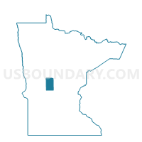
Browerville Voting District, Todd County, Minnesota
About
Outline

Summary
| Unique Area Identifier | 604630 |
| Name | Browerville Voting District |
| County | Todd County |
| State | Minnesota |
| Area (square miles) | 1.06 |
| Land Area (square miles) | 1.06 |
| Water Area (square miles) | 0.00 |
| % of Land Area | 100.00 |
| % of Water Area | 0.00 |
| Latitude of the Internal Point | 46.08073190 |
| Longtitude of the Internal Point | -94.86458210 |
Maps

Graphs
Select a template below for downloading or customizing gragh for Browerville Voting District, Todd County, Minnesota